BURLINGTON, ON CANADA – (March 4, 2020) – Qwhery, a leading #VoiceFirst service provider has been selected to join the Esri Startup Program, a three-year program that helps emerging business partners bring new and innovative products to customers of location intelligence world leader Esri.
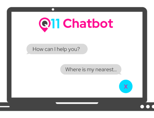
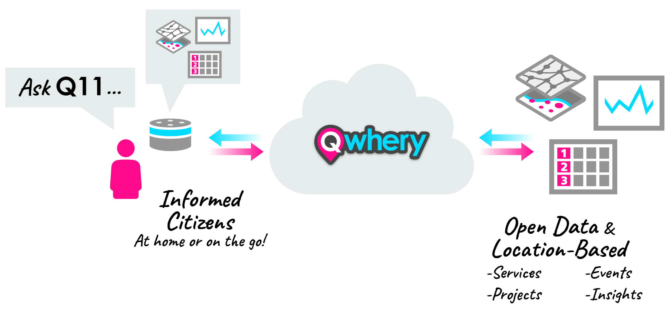
Qwhery is launching a set of skills called Q11, for voice assistant technology that connects authoritative municipal open data to Alexa-enabled devices, in homes or on mobile phones. In short, these Alexa skills offer a new channel for residents to ask their municipality questions about city services or submit service requests via their Amazon Echo devices. Qwhery has integrated these Alexa skills with the Esri Geospatial Cloud, a complete platform that provides mapping, business intelligence, analytics and IoT software.
Q-1-1
Q11 can provide users with location-based information from cities and regions, by using Alexa to connect to Open Data websites. It can be used to answer common questions about services, events, projects and provide local government insights.
After enabling the Alexa skill (just say, “Alexa, enable Q11“), users will be able to ask questions about city councilors or the ward that they live in, find out their waste collection schedule, ask when the next council or committee meeting is, find out what events are happening in town, zoning bylaw information for properties, and much, much more.
Skipping the Lines and Avoiding Wait Times
Cities and Citizens have benefited greatly from the three-number hotline 311. The result was quicker and more efficient resolutions for citizens and more data for cities to use to improve local government service delivery. But as populations grow, and budgets shrink, it gets more and more difficult to handle the volume of phone calls to 311 and meet municipal service levels.
Since its inception, 311 has evolved with technological advances into a multi-channel service that connects citizens with government, while also providing a wealth of data that improves how cities are run. Q11 is the modern way to get current information from your local government, instantly, from smart home and voice assistant devices.
Putting Municipal Open Data to Work
The questions within the Alexa skill that can be asked of your city is expanding as is the list of cities, towns and regions that are connecting their open data to Q11. “Municipalities are looking at ways to enhance their citizen engagement and at the same time thinking about digital transformation to modernize their service delivery” said Matt Pietryszyn, Founder and CEO, Qwhery. “Using ArcGIS Open Data, an Esri technology, cities can easily connect their open data to Q11, and begin to put their data to work.”
The Road Ahead
Qwhery is expanding the capabilities of Q11 and users will be able to opt-in or subscribe to notifications from their city. If there’s a planning development application submitted in their neighborhood, or there’s an event happening that is of interest, Q11 can notify you via your Alexa device.
Making payments and allowing users to submit problem reports are also on Qwhery’s roadmap for Q11. Qwhery is using voice technology and location intelligence to connect Smart Homes with Smart Cities.
About Qwhery
Qwhery, is a leader in implementing voice technology and geographic information systems. Their flagship product, Q11, connects smart home devices and voice assistants to local government open data portals. The Qwhery cloud helps Cities connect the services that they provide to their residents in a way that is truly unique – through smart home technology, open data and community engagement. More information can be found at Qwhery.com. Follow us on Twitter, Instagram, and LinkedIn.
About Esri
Esri, the global market leader in geographic information system (GIS) software, location intelligence, and mapping, offers the most powerful geospatial cloud available, to help customers unlock the full potential of data to improve operational and business results. Founded in 1969, Esri software is deployed in more than 350,000 organizations including 90 of the Fortune 100 companies, all 50 state governments, more than half of all counties (large and small), and 87 of the Forbes Top 100 Colleges in the US, as well as all 15 Executive Departments of the US Government and dozens of independent agencies. With its pioneering commitment to geospatial information technology, Esri engineers the most advanced solutions for digital transformation, the Internet of Things (IoT), and advanced analytics. Visit us at esri.com.
Esri Startup Program
The program is a global, free, three-year program that gives emerging businesses the tools to build mapping and location analytics capabilities into their products. Qualifying startups receive online services, software, training and support, content, and other opportunities to help them succeed.
About Esri Canada
Founded in 1984, Esri Canada provides geographic information system (GIS) solutions that empower people in business, government and education to make informed and timely decisions by leveraging the power of mapping and spatial analytics. These solutions enable organizations to better manage their resources, plan their future and collaborate within and beyond their organization. Esri Canada’s products and services help advance successful digital transformation. The company serves 12,000 organizations from 16 offices across Canada and is based in Toronto. In 2019, Esri Canada achieved Platinum Club status with the Canada’s Best Managed Companies program by retaining its Best Managed designation for seven consecutive years or more. More information can be found at esri.ca. Follow Esri Canada on Twitter, Facebook, YouTube, Instagram and LinkedIn.